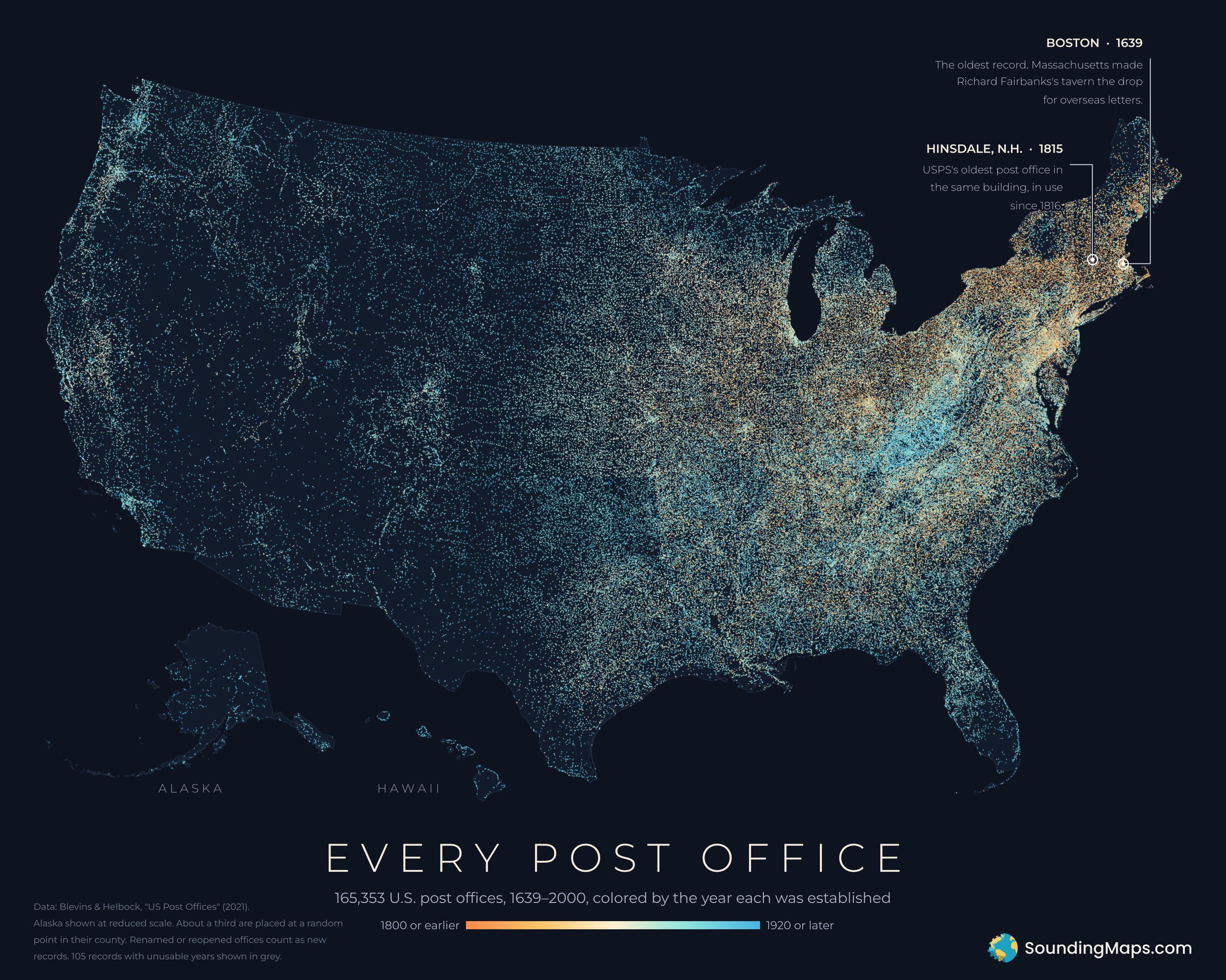
Before the railroad depot or the county courthouse, the surest sign that a place had become a place was often a post office. This map takes that literally. Every glowing dot is one of the 165,353 post offices recorded across the United States between 1639 and 2000, colored by the year it opened.
Read it east to west and you can watch the country fill in.
Where it started: Boston, 1639
The oldest dot on the map is in Boston. In 1639, the Massachusetts General Court named Richard Fairbanks’s tavern the official drop for letters going to and coming from overseas. Fairbanks got a penny a letter, and using his service was voluntary. It wasn’t yet a national mail system, but it’s where the record begins.
The next-oldest office in the dataset, Williamsburg, Virginia, doesn’t appear until 1699. After that, the dots thicken along the Atlantic: Hartford, New Haven and Bristol, R.I., all show up by 1773, and in 1775 the Continental Congress began building a postal network of its own. Those earliest offices glow ember-orange on the map, which is why New England and the mid-Atlantic coast look like they’re lit by firelight.
Hinsdale, N.H.: the post office that never moved
In the southwest corner of New Hampshire, in the Connecticut River town of Hinsdale, is a record of a different kind. Hinsdale’s post office was established in 1815. The next year its postmaster, Elijah Foot, moved it into a two-story wooden building on Main Street, and it’s still there. The U.S. Postal Service lists Hinsdale as its oldest post office in the same building, open at that address since 1816.
Most dots on this map came and went; Hinsdale has stayed put for more than two centuries.
The boom years
The 1880s were the busiest decade for new post offices: more than 31,000 opened in those ten years alone, followed by almost 28,000 in the 1890s. As settlers pushed west, the Post Office Department kept opening offices for new farm towns, mining camps and railroad stops.
Reconstructing the dataset year by year, roughly 77,800 post offices were open in 1900. That’s close to the Postal Service’s own count, which peaked at 76,945 in 1901. After that the number fell fast. Rural Free Delivery brought mail straight to farmhouses, which made thousands of tiny offices unnecessary. By 2000, only about 29,000 were left in the dataset (USPS counted 27,876).
Allegheny County: the county with the most
Zoom into western Pennsylvania and one county stands out. Allegheny County, home to Pittsburgh, has 331 post offices on record, more than any other county in the country. Pennsylvania as a whole leads every state, with more than 8,500 records. Coal patches, mill towns and river landings each got an office, and most didn’t last: only 59 of the 331 were still operating in 2000.
Another hotspot shows up as the bright blue patch over the central Appalachians. In the hills of eastern Kentucky, 79% of post offices opened in 1880 or later, around the time railroads and coal mining were reaching the region.
The ends of the map
The mail system’s far ends are the southernmost and northernmost post offices in the 50 states:
- Nāʻālehu, Hawaii, 1900. Near the southern tip of the Big Island, Nāʻālehu has the southernmost post office in the 50 states, according to USPS. The dataset’s Hawaii records start in 1900, the year the islands’ mail switched to U.S. stamps.
- Barrow, Alaska, 1901. The northernmost post office in the country sits on the Arctic Ocean in the town now called Utqiaġvik.
Alaska looks sparse because it is: a few hundred offices spread across an area larger than Texas, California and Montana combined.
How to read the map
Color shows the year each office was established, from orange (1800 or earlier) through ivory to blue (1920 or later). A few things to keep in mind:
- A new name counts as a new office. If an office was renamed, or reopened after being closed for 10 years or more, the dataset treats it as a new record. Denver, for example, appears as “Denver City” in 1860 and again as “Denver” in 1866.
- Some dots are placed by county. About a third of the offices couldn’t be matched to an exact location. Following the dataset authors’ advice for national maps, they’re placed at a random point inside their own county. So no single dot should be read as an exact address.
- A few records are missing. About 780 records have no known location, mostly ones with incomplete county information (including 57 in Alaska, where the dataset has no counties). About 100 records have missing or impossible years, such as an office closing before it opened, and are shown in grey.
Sources
- Data: Cameron Blevins and Richard W. Helbock, US Post Offices (Harvard Dataverse, 2021), using the version with semi-random coordinates for offices without an exact location.
- Boston, 1639: Smithsonian National Postal Museum, “Richard Fairbanks’ Tavern and Post Office.”
- Hinsdale: USPS Postal Facts, “Oldest Post Office (in the same building),” and the USPS history page “Oldest U.S. Post Offices.” The 1815 establishment year comes from the dataset.
- Nāʻālehu: USPS News Link (“Among the 50 states, the Naalehu, HI, Post Office is the most southern”); Hawaii’s switch to U.S. stamps on June 14, 1900, from Mystic Stamp Co.
- Post office counts by year: USPS, “Pieces of Mail Handled, Number of Post Offices, Income, and Expenses Since 1789.”
- Rural Free Delivery closures: Smithsonian National Postal Museum, “Closing Post Offices – The First Time Around.”
- Map details: Alaska is shown at reduced scale, and Hawaii and the Lower 48 at the same scale. The Lower 48 uses an Albers equal-area projection.