
In April 1863 the Union Army sent about 1,700 infantrymen deep into Alabama on mules.
The plan was bold. Col. Abel D. Streight would ride across North Alabama, cut the Western & Atlantic Railroad near Rome, Georgia, and choke off the supply line feeding Braxton Bragg’s Confederate army in Tennessee. Many of the mules turned out to be unbroken colts, and some were sick. The man chasing them was Nathan Bedford Forrest.
Two weeks later Streight surrendered his whole command in a field near Cedar Bluff, Alabama, to a force a fraction of his size.
What the map shows
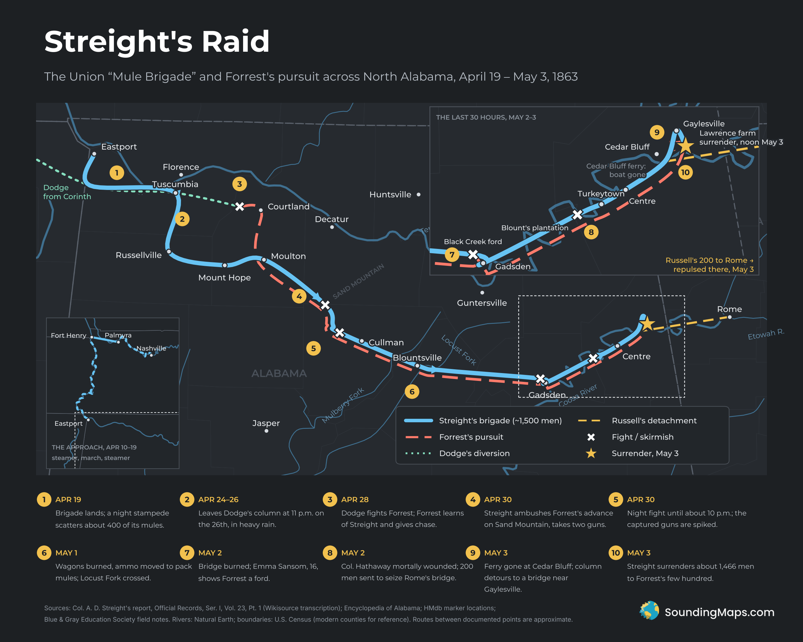
The main map follows Streight’s brigade (solid line) from the Tennessee River at Eastport, Mississippi, to the surrender site east of Cedar Bluff. Forrest’s pursuit (dashed) joins near Town Creek and stays on the brigade’s heels for the rest of the march. Two other movements complete the picture: Grenville Dodge’s diversionary column (dotted) and the 200-man detachment Streight sent ahead to Rome (yellow dashed).
The lower-left inset shows how the brigade got to Eastport in the first place: by steamer from Nashville, overland to Fort Henry, then by steamer up the Tennessee. The upper-right inset zooms in on the last 30 hours, when the chase came down to burned bridges, a missing ferry and a farm girl who knew a ford.
A bad start: Nashville to Tuscumbia
The trouble started before the raid did. In his official report, Streight described the mules issued at Nashville as poor, unbroken colts, many of them sick with distemper. On the march from Palmyra to Fort Henry he lost about 100 more.
At Eastport on the night of April 19, the brigade’s mules stampeded. About 400 got loose and only about half were recovered. Streight spent days collecting replacements and joined Dodge’s larger column at Tuscumbia on April 24. Dodge’s job was to push east along the Tennessee River and keep the Confederate cavalry busy.
At 11 p.m. on April 26, in pouring rain, Streight’s brigade slipped south out of Tuscumbia toward Russellville, Mount Hope and Moulton.
Day’s Gap and Hog Mountain
Dodge fought Forrest at Town Creek on April 28, and Forrest soon worked out what was going on. He turned and rode after Streight with part of his command.
He caught him before dawn on April 30 at Day’s Gap, where the road climbs onto Sand Mountain. Streight laid an ambush on the ridge, and his men charged the Confederate advance and captured two cannon. It was the raid’s best moment.
It didn’t slow Forrest down much. That evening he struck again at Hog Mountain, about 10 miles further on, and the fighting went on in the dark until around 10 p.m. Streight’s men ran out of ammunition for the captured guns, spiked them and moved on through the night.
The long run east
From there the raid became a running fight with almost no rest. The brigade reached Blountsville on the morning of May 1, burned its wagons and moved its ammunition onto pack mules. It held off Forrest’s men at the crossing of the Locust Fork (the “East Branch” of the Black Warrior River in Streight’s report) and kept going.
On May 2 the column crossed Black Creek, just west of Gadsden, and burned the only bridge. That should have bought hours. Instead, 16-year-old Emma Sansom rode behind Forrest and showed him a ford nearby, and the Confederates were across almost at once.
That afternoon at Blount’s plantation, about 15 miles past Gadsden, Streight’s rear guard fought again. Col. Gilbert Hathaway of the 73rd Indiana was mortally wounded. Streight sent Capt. Milton Russell ahead with 200 of the best-mounted men to seize the bridge at Rome before the Confederates could reach it.
The last 30 hours
The night march that followed is where the raid fell apart. Streight’s report notes that much of the column’s ammunition had been soaked crossing creeks. In the dark, exhausted men and animals strung out across broken country near the Round Mountain iron works.
At the Chattooga River near Cedar Bluff, Russell’s advance party had crossed by ferry, but by the time the main column arrived the boat was gone. Streight turned upstream and crossed on a bridge near Gaylesville, burning it behind him. Meanwhile, in Rome, a local warning had already arrived, and Russell’s detachment was turned back from the city.
On the morning of May 3 the brigade stopped to feed its animals near the Lawrence farm east of Cedar Bluff. Forrest caught up with them there.
Forrest’s bluff
What happened next is the part everyone remembers. Forrest had only a few hundred men with him (a 1939 marker at the site says 322). During the surrender talks he reportedly kept the same few guns and units moving in and out of view, so that Streight would think he faced a much larger force.
It worked. Streight surrendered about 1,466 men around noon on May 3. Accounts agree he was furious when he saw how few Confederates there really were.
Most of the prisoners were taken to Richmond, and Streight ended up in Libby Prison. In 1864 he got out through a tunnel along with more than a hundred other prisoners.
Sources and methodology
Primary source
- Col. Abel D. Streight, report dated August 22, 1864, The War of the Rebellion: Official Records of the Union and Confederate Armies, Series I, Vol. 23, Part 1. Read via the transcription on Wikisource. Used for dates, times, camps, river crossings, the Russell detachment, and the Chattooga crossing near Gaylesville.
Secondary sources and locations
- Encyclopedia of Alabama, “Streight’s Raid”: overall narrative, Emma Sansom, and the defense of Rome.
- Wikipedia, “Streight’s Raid” and “Battle of Day’s Gap”: the itinerary, casualty figures and the Day’s Gap coordinates.
- Historical Marker Database: the surrender marker near Cedar Bluff (source of the 322 / 1,466 figures and the surrender-site location), the Streight’s Raid marker near Hog Mountain, the Emma Sansom monument in Gadsden, and the Chattooga River marker at Gaylesville.
- Blue & Gray Education Society field-trip report: site sequence for Day Farm, the Locust Fork crossing, the Blount plantation, Round Mountain and the Lawrence farm.
Mapping notes: Town locations are modern coordinates. Eastport and Fort Henry are now under TVA reservoirs, and their positions are approximate. The routes connect documented points with smoothed lines, so they show the general line of march, not exact roads. Blount’s plantation and Turkeytown are placed by the distances given in period accounts. Rivers come from Natural Earth. Modern county lines are shown faintly for reference only.