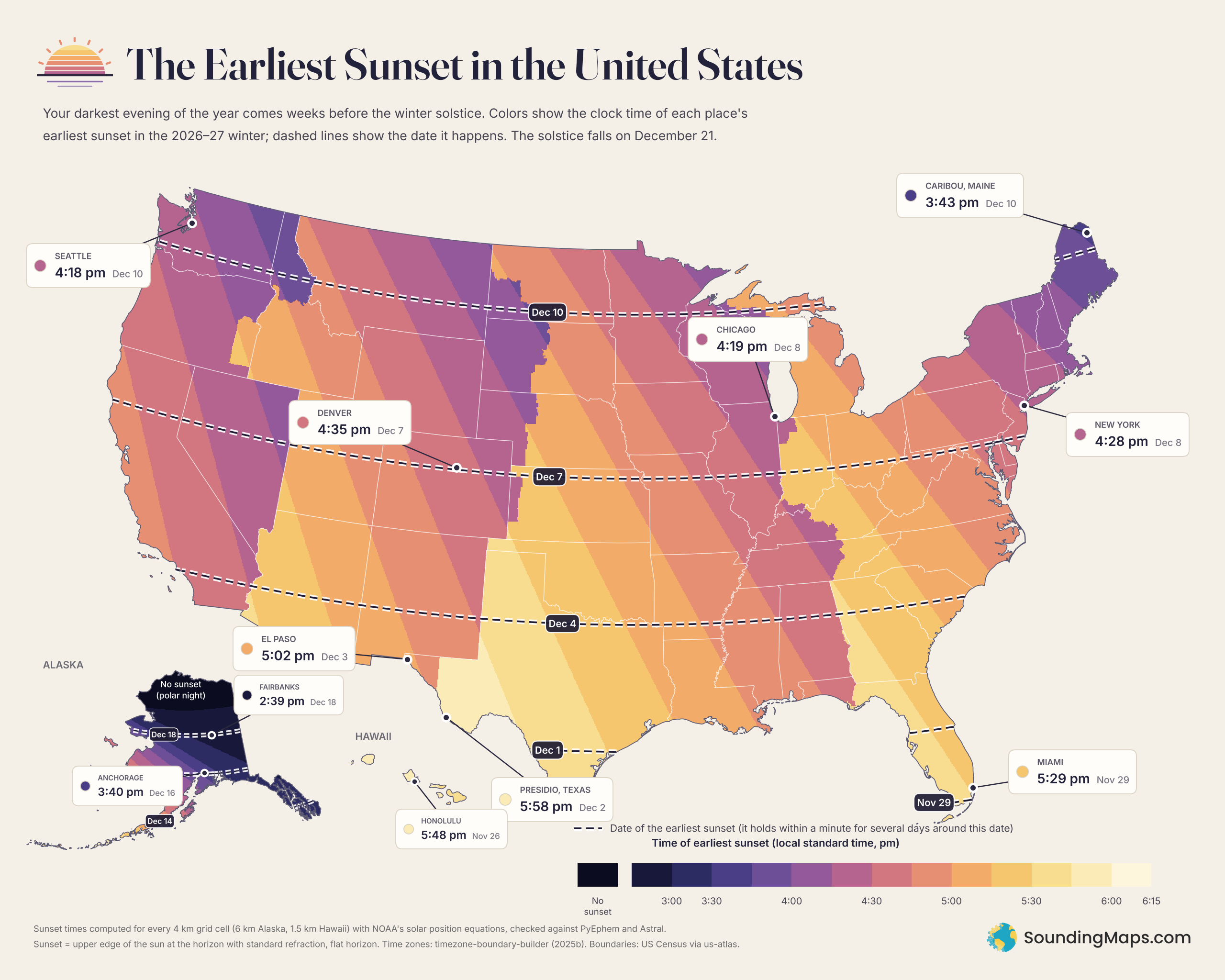
New York City’s earliest sunset this winter comes at 4:28 pm, and it arrives around December 8. By the winter solstice on December 21, sunset has already slipped to about 4:32. On New Year’s Day it comes at 4:39.
That pattern holds across the country. The shortest day and the earliest sunset are two different events. This map shows when and how early that darkest evening arrives wherever you live.
What The Sunset Map Shows
Colors show the clock time of each place’s earliest sunset in the 2026–27 winter, in local standard time. Dark purples mark places where the sun sets before 4 pm. Pale gold marks places where it holds on until almost 6.
Dashed lines show the date of the earliest sunset. In South Florida and the Rio Grande Valley it comes in late November. Through the middle of the country it lands in the first week of December. Along the Canadian border it slides to around December 10.
Clock times barely move near that date. New York’s sunset stays within one minute of 4:28 from about December 1 to December 14. So the date on the map marks the middle of a plateau that lasts a week or two.
Why The Earliest Sunset Comes Before The Solstice
Two things set the time of sunset. The first is day length, which bottoms out at the solstice. Second comes the time of solar noon, the moment the sun stands highest.
Solar noon drifts later by about half a minute per day in December. Earth’s tilted axis and its elliptical orbit cause that drift, which astronomers call the equation of time. Early in December, the later solar noon outweighs the shrinking afternoon. Sunsets start getting later while the days still get shorter.
Mornings run the other way. Sunrise keeps getting later until early January, so the latest sunrise also misses the solstice.
Time Zones Shape Rhe Map More Than Latitude
The sharpest color changes follow time zone lines, not latitude. Within a zone, the sun sets earlier on the eastern edge than on the western edge. Each degree of longitude is worth four minutes.
That explains the map’s two extremes in the lower 48. Far northern Maine sits at the eastern edge of the Eastern zone and close to Canada. Its earliest sunset comes at about 3:42 pm, around December 10. Caribou sees 3:43.
Presidio, Texas, sits at the far western edge of the Central zone, far to the south. Its earliest sunset comes around December 2 at about 5:58 pm. El Paso lies only about 200 miles away but uses Mountain time. It gets dark at 5:02.
Other pockets follow the same rule. Michigan’s Upper Peninsula, Indiana and central Kentucky sit at the western edge of the Eastern zone. They get late sunsets. Western North Dakota, western Nebraska and Idaho’s panhandle sit at the eastern edges of their zones. Their sunsets come early.
By area, about 13% of the lower 48 sees its earliest sunset before 4:30 pm. About 21% keeps its sunset at 5:00 or later.
Alaska and Hawaii
Alaska runs off the chart. Anchorage’s earliest sunset comes at 3:40 pm around December 16. Fairbanks sees 2:39 pm around December 18. North of roughly 67° latitude, the sun doesn’t rise for part of the winter. Those areas go without a sunset for a stretch.
Hawaii sits much closer to the equator, so its earliest sunset comes earliest on the calendar. Honolulu’s arrives around November 26 at 5:48 pm.
Earliest Sunsets for Cities in the United States
| City | Time zone | Earliest sunset | Date |
|---|---|---|---|
| The 50 largest US cities, earliest to latest | |||
| Boston, MA | Eastern | 4:11 pm | Dec 8 |
| Milwaukee, WI | Central | 4:17 pm | Dec 9 |
| Seattle, WA | Pacific | 4:18 pm | Dec 10 |
| Chicago, IL | Central | 4:19 pm | Dec 8 |
| Las Vegas, NV | Pacific | 4:26 pm | Dec 5 |
| Portland, OR | Pacific | 4:27 pm | Dec 10 |
| New York, NY | Eastern | 4:28 pm | Dec 8 |
| Minneapolis, MN | Central | 4:31 pm | Dec 9 |
| Nashville, TN | Central | 4:32 pm | Dec 5 |
| Aurora, CO | Mountain | 4:35 pm | Dec 7 |
| Denver, CO | Mountain | 4:35 pm | Dec 7 |
| Philadelphia, PA | Eastern | 4:35 pm | Dec 7 |
| Colorado Springs, CO | Mountain | 4:37 pm | Dec 7 |
| San Diego, CA | Pacific | 4:42 pm | Dec 3 |
| Fresno, CA | Pacific | 4:43 pm | Dec 6 |
| Baltimore, MD | Eastern | 4:43 pm | Dec 7 |
| Bakersfield, CA | Pacific | 4:43 pm | Dec 5 |
| Los Angeles, CA | Pacific | 4:43 pm | Dec 4 |
| Long Beach, CA | Pacific | 4:44 pm | Dec 4 |
| Sacramento, CA | Pacific | 4:45 pm | Dec 6 |
| Washington, DC | Eastern | 4:46 pm | Dec 7 |
| Virginia Beach, VA | Eastern | 4:47 pm | Dec 6 |
| Memphis, TN | Central | 4:48 pm | Dec 5 |
| San Jose, CA | Pacific | 4:50 pm | Dec 6 |
| Oakland, CA | Pacific | 4:50 pm | Dec 6 |
| San Francisco, CA | Pacific | 4:51 pm | Dec 6 |
| Omaha, NE | Central | 4:54 pm | Dec 8 |
| Albuquerque, NM | Mountain | 4:54 pm | Dec 5 |
| Kansas City, MO | Central | 4:55 pm | Dec 7 |
| Detroit, MI | Eastern | 5:00 pm | Dec 8 |
| Raleigh, NC | Eastern | 5:01 pm | Dec 5 |
| El Paso, TX | Mountain | 5:02 pm | Dec 3 |
| Columbus, OH | Eastern | 5:07 pm | Dec 7 |
| Tulsa, OK | Central | 5:09 pm | Dec 5 |
| Charlotte, NC | Eastern | 5:11 pm | Dec 5 |
| Oklahoma City, OK | Central | 5:17 pm | Dec 5 |
| Tucson, AZ | Mountain (Arizona) | 5:19 pm | Dec 3 |
| Mesa, AZ | Mountain (Arizona) | 5:19 pm | Dec 4 |
| Indianapolis, IN | Eastern | 5:20 pm | Dec 7 |
| Phoenix, AZ | Mountain (Arizona) | 5:20 pm | Dec 4 |
| Dallas, TX | Central | 5:21 pm | Dec 4 |
| Houston, TX | Central | 5:22 pm | Dec 2 |
| Louisville, KY | Eastern | 5:23 pm | Dec 6 |
| Fort Worth, TX | Central | 5:23 pm | Dec 4 |
| Jacksonville, FL | Eastern | 5:26 pm | Dec 2 |
| Atlanta, GA | Eastern | 5:29 pm | Dec 4 |
| Miami, FL | Eastern | 5:29 pm | Nov 29 |
| Austin, TX | Central | 5:30 pm | Dec 2 |
| Tampa, FL | Eastern | 5:34 pm | Dec 1 |
| San Antonio, TX | Central | 5:35 pm | Dec 2 |
| Alaska and Hawaii | |||
| Fairbanks, AK | Alaska | 2:39 pm | Dec 18 |
| Juneau, AK | Alaska | 3:06 pm | Dec 15 |
| Anchorage, AK | Alaska | 3:40 pm | Dec 16 |
| Honolulu, HI | Hawaii | 5:48 pm | Nov 26 |
| Lower 48 extremes | |||
| Caribou, ME | Eastern | 3:43 pm | Dec 10 |
| Presidio, TX | Central | 5:58 pm | Dec 2 |
Methodology and Sources
I computed sunset times for every day from November 1, 2026, to January 31, 2027. The grid uses 4 km cells in the lower 48, 6 km in Alaska and 1.5 km in Hawaii. All calculations follow NOAA’s solar position equations. Sunset means the moment the sun’s upper edge touches a flat horizon, with standard atmospheric refraction.
For each cell I found the day with the earliest clock time. A smooth curve through neighboring days places the dashed date lines. City dates mark the single day with the earliest sunset. Because the times barely change, other methods may land a day off. I spot-checked ten cities against two independent libraries, PyEphem and Astral. They agreed within about one minute.
Time zones come from the timezone-boundary-builder project (release 2025b), with December offsets from the IANA time zone database. State outlines come from US Census boundaries via the us-atlas package.
Real sunsets can differ by a minute or two from these figures. Hills, mountains, elevation and unusual air temperatures all shift the moment slightly. Times are rounded to the nearest minute.