“At evening we came in sight of a house which was the first we had seen for the space of 31 days.” Private Abner Stocking wrote that on November 3, 1775, on the Chaudière River in Quebec. He had left Cambridge, Massachusetts, seven weeks earlier.
Stocking was one of about 1,100 volunteers Benedict Arnold led north that fall. Their goal was to take Quebec City by surprise. About 600 of them reached the St. Lawrence River.
Why Arnold went north
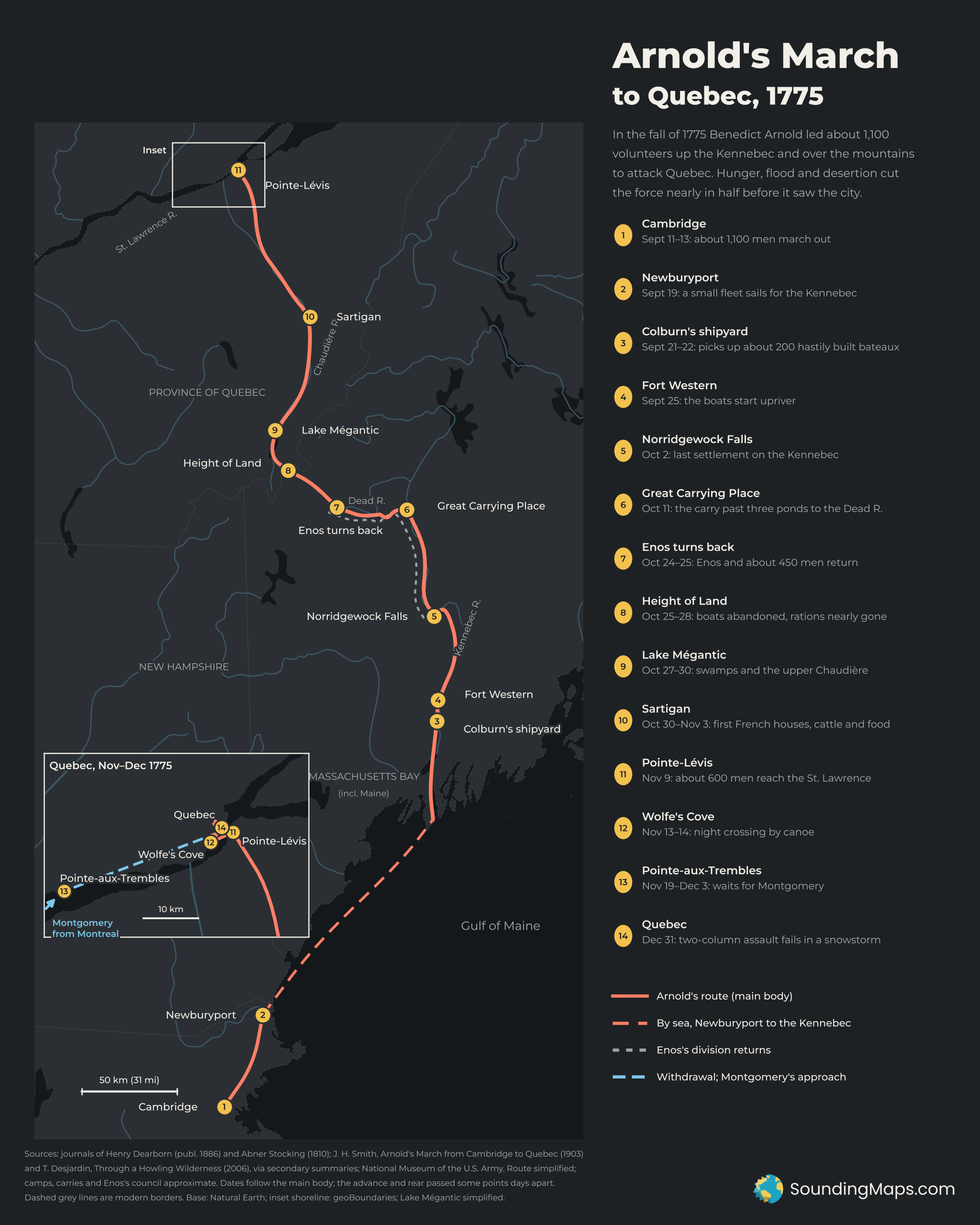
In the summer of 1775, Congress sent a force up Lake Champlain toward Montreal. Richard Montgomery soon took command of it. George Washington approved a second force to strike Quebec from the east. Arnold proposed the route: up Maine’s Kennebec River, over the mountains and down the Chaudière to the St. Lawrence.
Planners expected about 180 miles from Fort Western to Quebec, taking about 20 days. The march took nearly seven weeks.
Up the Kennebec
The men left Cambridge between September 11 and 13 and marched to Newburyport. A small fleet carried them up the coast to the Kennebec on September 19.
At Gardinerston, Reuben Colburn’s shipyard had built about 200 bateaux for the army. These flat-bottomed boats were made of green lumber in a hurry, and many soon leaked. The troops set out from Fort Western, at today’s Augusta, on September 25.
The river had falls at Ticonic, Skowhegan and Norridgewock. At each, the men carried boats and barrels around the rapids on their backs. Norridgewock Falls, reached on October 2, was the last settlement on the route.
The Great Carrying Place and the Dead River
Above Norridgewock the Kennebec runs north toward the mountains. Around October 11, most of the force reached the Great Carrying Place. There the army left the Kennebec and headed west, crossing three ponds to reach the Dead River.
Heavy rain then flooded the Dead River. On October 22 the water rose over the camps, and several bateaux overturned with their food.
Enos turns back
On October 24 and 25, the rear division under Lieutenant Colonel Roger Enos held a council. Enos and about 450 men turned back toward Cambridge. By most accounts they took a large share of the food with them.
Arnold pushed ahead with the rest. Around October 25 the advance party crossed the Height of Land into Quebec. Most of the remaining boats were left behind there.
Starvation on the Chaudière
The men then struggled through swamps near Lake Mégantic. Some companies got lost for days. Stocking recorded that Captain Goodrich’s company killed a large black dog for food.
The first French farms appeared near Sartigan, today’s Saint-Georges, at the start of November. Arnold had gone ahead to buy cattle and flour, which reached the starving columns along the river.
Quebec
The main body reached Pointe-Lévis, across the river from Quebec, on November 9. On the night of November 13–14, about 500 men crossed the St. Lawrence by canoe. They landed at Wolfe’s Cove, where British troops had come ashore in 1759.
The city’s defenders refused to come out and fight. Arnold had no artillery, and some of his powder had been ruined on the march. On November 19 he withdrew west to Pointe-aux-Trembles to wait for Montgomery.
Montgomery arrived on December 3, and the combined force returned to the city. They attacked before dawn on December 31, in a snowstorm. Montgomery’s column moved along the river below Cap Diamant, and Arnold’s column hit the Lower Town from the north.
Montgomery was killed at the first barricade. Arnold was shot in the leg and carried to the rear. Daniel Morgan led Arnold’s column into the Lower Town, where it was surrounded. Morgan and hundreds of others, including Stocking, were taken prisoner.
Methodology and sources
- Primary sources: Abner Stocking, An Interesting Journal of Abner Stocking of Chatham, Connecticut (1810), on Project Gutenberg. Journal of Captain Henry Dearborn in the Quebec Expedition, 1775 (published 1886), on the Internet Archive.
- Secondary sources: Justin H. Smith, Arnold’s March from Cambridge to Quebec (1903), which reprints Arnold’s own journal, and Thomas Desjardin, Through a Howling Wilderness (2006). I relied on published summaries of these for some dates. The National Museum of the US Army’s online “Army Trail” pages filled in other details.
- Dates: Journals disagree by a day or two, because the advance party and rear divisions passed each point at different times. The map gives dates for the main body. Some accounts date the river crossing to November 11–12. This map follows Arnold’s dating of November 13–14.
- Locations: Rivers and the main-map coastline come from Natural Earth. The Quebec inset uses the more detailed geoBoundaries shoreline, since Natural Earth places Quebec City in the river at that scale. Waypoints are placed from modern locations of the historic sites. Camps, the carry ponds and the site of Enos’s council are approximate. Lake Mégantic is drawn as a simplified outline. Dashed grey lines are modern borders, shown only for reference.